By C. M. Ellingham, Times-Observer Historical Correspondent
The city of Inverness, now the political and cultural centre of Eyehasseen, began its existence under far humbler circumstances. In its earliest form, the settlement was little more than a fortified river post standing on the northern bank of the Caelish River, established to guard a crossing that had become increasingly vulnerable to raiders and smugglers. The decision to found the outpost was made in the year 312, during the reign of King Aldric I, at a time when the northern and eastern territories were unevenly settled and still marked by long stretches of wilderness.
The site was chosen not for its comfort but for its strategic advantage. The Caelish River narrowed there between two firm banks, allowing carts and livestock to ford the water in most seasons. Traders from the eastern highlands and farmers from the lower valley used the route frequently, yet it was unprotected. Bands of opportunists had taken to levying illegal tolls, and several attacks on merchant caravans finally prompted the Crown to take action. A permanent garrison post, it was believed, would secure the region and give the King greater oversight of movements along the frontier.
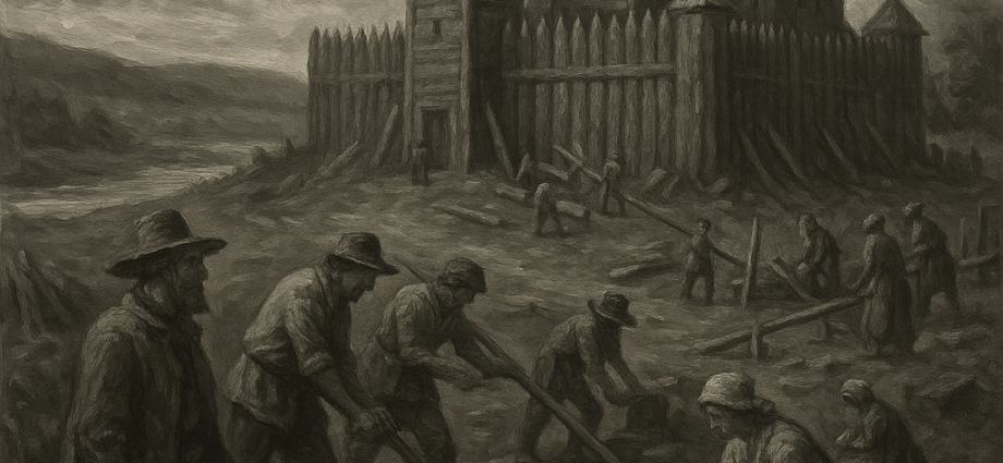
The initial structure, known as Fort Caelish, consisted of a timber palisade reinforced with earthworks, enclosing a parade ground, barracks, a storehouse, and a small command building. The garrison numbered fewer than sixty men at first—most were veterans of the southern border campaigns, reassigned to what they presumed would be quieter duty. Conditions were difficult. Contemporary diaries mention persistent flooding, biting insects, and dense morning fogs that obscured visibility along the river. Supplies arrived irregularly, and the men relied heavily on local farmers and hunters for provisions.
Yet the fort’s presence produced immediate effects. Those who had previously avoided the crossing returned to their old routes, confident that the garrison offered protection. Small stalls began to appear along the roadside outside the palisade where traders exchanged grain, tools, hides, and livestock. A pair of enterprising millers constructed a modest watermill upstream. With trade resumed, and with the fort providing a degree of security, the settlement that would become Inverness began to form.
By the 330s, the original palisade had been expanded twice to accommodate additional soldiers and storehouses. The region’s population grew as farmers and craftsmen migrated to the area, encouraged by the Crown’s grant of favourable tenancies for those willing to establish homesteads within five miles of the fort. A small chapel, dedicated to St. Ruan, was erected near the eastern gate, and a market square developed organically around it. The settlement was still small, but for the first time it possessed the beginnings of a civic structure.
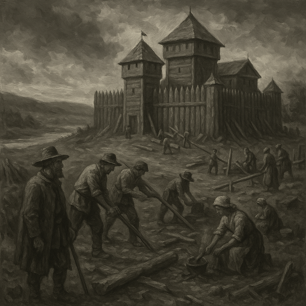 The decisive change occurred in 356, when King Aldric II ordered the construction of stone fortifications to replace the ageing timber walls. This project, directed by the royal engineer Master Halran Duval, marked a turning point in the settlement’s history. Duval was an accomplished builder known for his precise surveying methods and his ability to adapt fortification styles to the terrain. Under his guidance, the original footprint of the fort was reshaped into a more defensible configuration, with continuous stone curtain walls, square towers at the corners, and a main gatehouse capable of withstanding prolonged assault.
Duval encountered several challenges—not least the marshy ground near the riverbank. To overcome this, he supervised the laying of deep foundations filled with compacted stone. The construction, which took nearly four years, provided employment for hundreds of local labourers and drew stonemasons from as far as Thornwold. When the walls were completed, Fort Caelish was no longer a frontier post but a formidable stronghold. The King renamed it Castle Inverness, drawing upon the old dialect word Inver for “river mouth,” although the modern river no longer reaches the sea.
The presence of the new fortress spurred rapid growth. Merchants found the location ideal for storing and exchanging goods, and a formal marketplace was chartered in 361. Inns, workshops, and permanent dwellings multiplied along the main road. The settlement’s position at the junction of several trade routes allowed it to flourish economically, and by the early 400s Inverness had surpassed older towns in both size and influence.
Two events in the 5th century solidified its role as the leading city of the realm. The first was the Great Fire of 411, which destroyed a significant portion of the wooden structures in the lower town, leaving hundreds without shelter. Though disastrous, the fire led to stricter building regulations, including the requirement that houses near the central square be built of stone. Reconstruction efforts were coordinated by the Crown, which temporarily stationed additional engineers and administrators in the city. Their presence laid the groundwork for a more permanent governmental apparatus.
The second event came in 428, when King Regulus I relocated his seasonal court from Westmere to Inverness. Chroniclers of the time describe the King as impressed by the city’s defensibility, its central position, and its steady growth. Once the royal household and its attendant bureaucracy began to spend greater time there, Inverness transformed from a prosperous town into a political centre. Embassies, noble residences, and trade guild headquarters soon followed.
It was not until 452, under Queen Maerwyn, that Inverness was formally declared the capital of Eyehasseen, though in practice it had acted as such for some years. The proclamation prompted the construction of new civic buildings, including the Hall of Records, the Royal Mint, and the original Council Chamber. The city’s population expanded sharply, and its urban boundaries spread beyond the old fortification walls.
By the 6th century, Inverness had taken on much of the character it retains today: a royal seat, a commercial hub, and a symbol of the kingdom’s cohesion. Still visible in the modern city are remnants of the early structures—the line of the first stone curtain wall, preserved in portions of the Old Quarter; the chapel of St. Ruan, restored several times but still on its original foundation; and the old ford, no longer used for crossings but marked by a stone pillar bearing the date of the settlement’s founding.
From a remote outpost on a troubled riverbank to the throne-city of Eyehasseen, Inverness’s rise was the product of steady growth, careful planning, and the persistent efforts of both ordinary settlers and capable administrators. Its history reflects the kingdom’s broader development: resilient in hardship, adaptive in governance, and shaped by the geography that first gave it purpose.